

Key facts
- NASA provides an educator page with K–12 collections on aeronautics, Earth science, the Moon, climate, eclipses, the solar system, and activities related to the International Space Station.
- The Canadian Space Agency recommends using space as a context for subjects such as science, mathematics, history, geography, language arts, and art.
- Examples from the Canadian agency include pollination activities for K–2 and grades 3–5, and a water-recovery challenge for a lunar station intended for grades 3–8.
- Living Space, a resource created and managed by Let's Talk Science, originally with support from the Canadian Space Agency, is designed for grades 6–9 and proposes measuring classroom temperature, humidity, and carbon dioxide to make decisions based on the data.
- The UK Space Agency guide mentions ESERO-UK resources for elementary and secondary school and a satellite-themed escape challenge for ages 7–11.
- The two original CosmoInsider activities propose describing lunar and Martian features, separating observation from interpretation, and recording the limitations of scale and images.
Related records
Space exploration offers concrete problems that connect subjects: how to obtain water, what can be observed from a satellite, or how to communicate a decision during a mission. The Canadian Space Agency explicitly proposes using space as a context for teaching science, biology, mathematics, history, geography, and art, and suggests collaboration across areas such as language arts and music. This idea can be adapted for an elementary or secondary classroom by choosing an age-appropriate question and connecting it to learning objectives in each subject.
One topic, different subjects
Science: investigate and design
An activity about pollination can introduce the relationship between plants and pollinators; the Canadian Space Agency distinguishes between one proposal for K–2 and another for grades 3–5. For students in grades 3–8, it also describes the challenge of inventing a water-recovery system for a lunar station. In a teacher-led adaptation, students can identify the problem to solve, propose a solution, and explain what they would need to test to evaluate their design. These are examples from the Canadian agency, not NASA programs.
Mathematics: measure, represent, and decide
The same agency presents Robomaths as a resource for practicing angles and geometric transformations. It also recommends Living Space, a resource created and managed by Let's Talk Science, originally with support from the Canadian Space Agency. Designed for grades 6–9, it invites students to measure classroom temperature, humidity, and carbon dioxide, compare their results with levels considered optimal, and use the data to decide whether conditions should be improved. It shows how measurement and analysis can be central to an investigation, rather than calculations being added without connection to the problem.
Geography and Earth science: looking down from above
The Canadian Space Agency suggests exploring geography and Earth through photographs taken by astronauts and satellite images georeferenced on a map. An activity could ask students to observe an image, locate the place, and describe the features they recognize. In higher grades, students could compare images or write an explanation of what they reveal. The task and level of interpretation should match what the class has already studied.
Language arts, history, and art: explain, narrate, and represent
Space also offers topics for practicing writing and oral communication. The Canadian agency suggests poems, opinion pieces about the benefits of space exploration, and blog posts about space news; it also mentions its bilingual French-English materials for language practice. For history, it proposes studying milestones in Canada’s space program. As an art activity, it suggests creating a collaborative space mural. These examples can be adapted for other subjects: for instance, ask a group to accompany an illustration with an explanatory text or to defend a mission proposal orally.
How to adapt an activity to the grade level
Before choosing a resource, check which ages or grades it is designed for and what prior knowledge, reading, calculations, or materials it requires. The age indicated for an activity is a guide, not a reason to use it without adaptation: teachers can simplify instructions, provide visual supports, divide the work into steps, or ask older students for more analysis and justification.
- Elementary school: prioritize a clear question, direct observations, brief instructions, and a tangible product, such as an annotated drawing, a classification, or a model. The pollination proposals for K–2 and grades 3–5 are examples differentiated by level.
- Middle grades: combine measurements, observation records, and straightforward decisions. The water-recovery challenge for grades 3–8 shows how one topic can span several grades; teachers can adjust the complexity of the design and explanation.
- Secondary school: allow more time for data, argumentation, and evaluation of solutions. Living Space, a resource managed by and created by Let's Talk Science, originally with support from the Canadian Space Agency, is designed for grades 6–9 and includes measurements and decisions based on results; satellite images can support work in geography and Earth science.
The Canadian Space Agency also describes a mission simulation: assign roles—for example, mission control, astronaut, or robotics operator—set an objective, and introduce setbacks. According to its proposal, this helps students practice teamwork, communication, decision-making, and risk management. It is an activity from that agency and should not be presented as an official NASA activity.
A flexible sequence for the classroom
The following sequence is a teaching suggestion, not an official program from NASA or the other agencies mentioned. It can take one class period or be spread over several sessions, depending on the topic and grade level.
- Ask a question: for example, how water could be recovered on a lunar station or what information a satellite image provides. Ask the class to share what they know and what they need to find out.
- Investigate: consult a resource suited to the grade level and separate questions by subject: scientific concepts, measurements, geographic location, or vocabulary.
- Work with evidence or develop a proposal: analyze an image, record measurements, practice a mathematical skill, or design a solution. Choose a task that can be completed with the available time and materials.
- Communicate the result: create a text, presentation, annotated drawing, mural, or prototype, and explain which data or ideas support the proposal.
- Review and assess: check what was learned, which parts of the work are supported by evidence, and what the class would change if it started again.
How to find and evaluate NASA resources
The most direct starting point is NASA’s official resources for educators page. It brings together educational opportunities for different settings and presents K–12 collections organized by topics, including aeronautics, Earth science, the Moon, climate, eclipses, the solar system, and activities related to the International Space Station. From there, teachers can use the resource search and filters to explore materials.
Before bringing a proposal into the classroom, it is useful to check:
- Who publishes it: determine whether the resource comes from NASA, another space agency, or an educational organization.
- Who it is for: look for the stated age, grade, or level and decide whether it fits the particular class.
- What it aims to teach: connect the activity to the subject and lesson objective instead of choosing it only because it mentions space.
- What it takes to use: check the instructions, time, materials, and any technology requirements before planning.
- What information it provides about its content: consider whether it explains the concepts and data it uses, and whether students can show how they reached their conclusions.
These criteria are a practical selection guide, not a list of NASA certifications. An activity about space is not automatically a NASA resource: its authorship should be checked on the relevant page.
Other sources as supplements
The Canadian Space Agency offers ideas by grade and subject, including proposals about pollination, mathematics, Earth observation, and writing. The UK Space Agency’s educational resources guide, in turn, lists ESERO-UK materials for elementary and secondary school and mentions educational resources from the European Space Agency (ESA). One example it includes is a satellite-themed escape challenge for ages 7–11, created by the Centre for Satellite Data in Environmental Science (SENSE) and related to science and geography.
These options are supplementary references, not replacements for NASA’s institutional materials or NASA programs. In each case, check the responsible organization, intended audience, and educational context to assess whether the resource fits the classroom.
References for teachers
- NASA: Learning Resources for Educators.
- Canadian Space Agency: Ideas for Bringing Space into the Classroom.
- UK Space Agency: Space-Related Educational Resources.
Two original activities: observing the Moon and Mars
These CosmoInsider activities help students practice an important distinction: describing what is visible is not the same as explaining how it formed. They are not official activities from NASA, Space Grant, or a university. The ages and timings below are suggested planning guidance for teachers, not results from a classroom trial or alignment with an official curriculum.
Prepare the images and the observation record
Each pair needs images A and B, paper, a pencil, and a ruler; the images can be projected or printed with their credits. Preserve the framing, annotations, and scale bar. Also provide the written descriptions to anyone who cannot distinguish small details or colors.
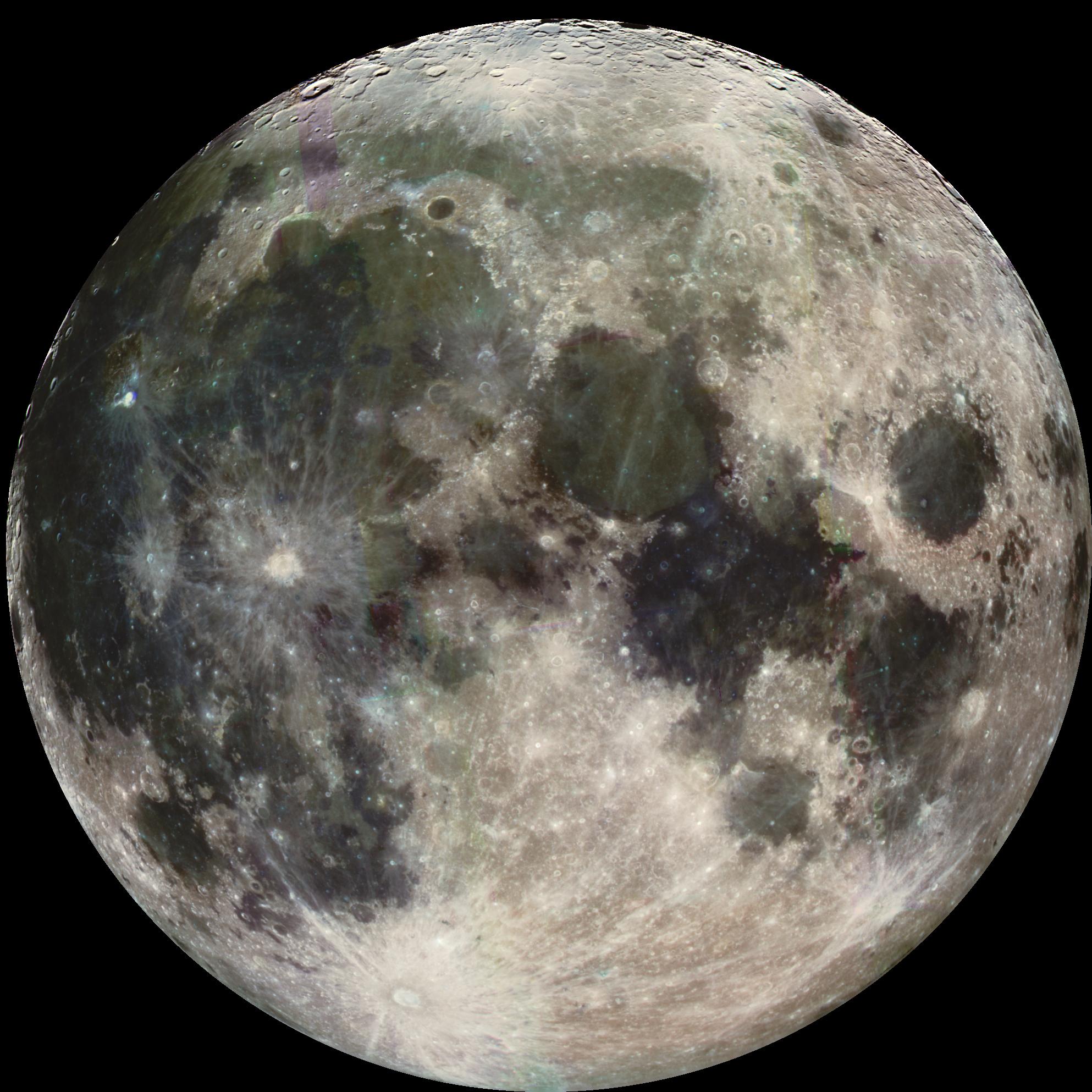
- Image A: open or download lunar image PIA00405. A composite of images obtained on December 7, 1992, with enhanced color derived from different filters; it does not represent natural color. Credit: NASA/JPL/USGS. Its institutional record is listed in the references.
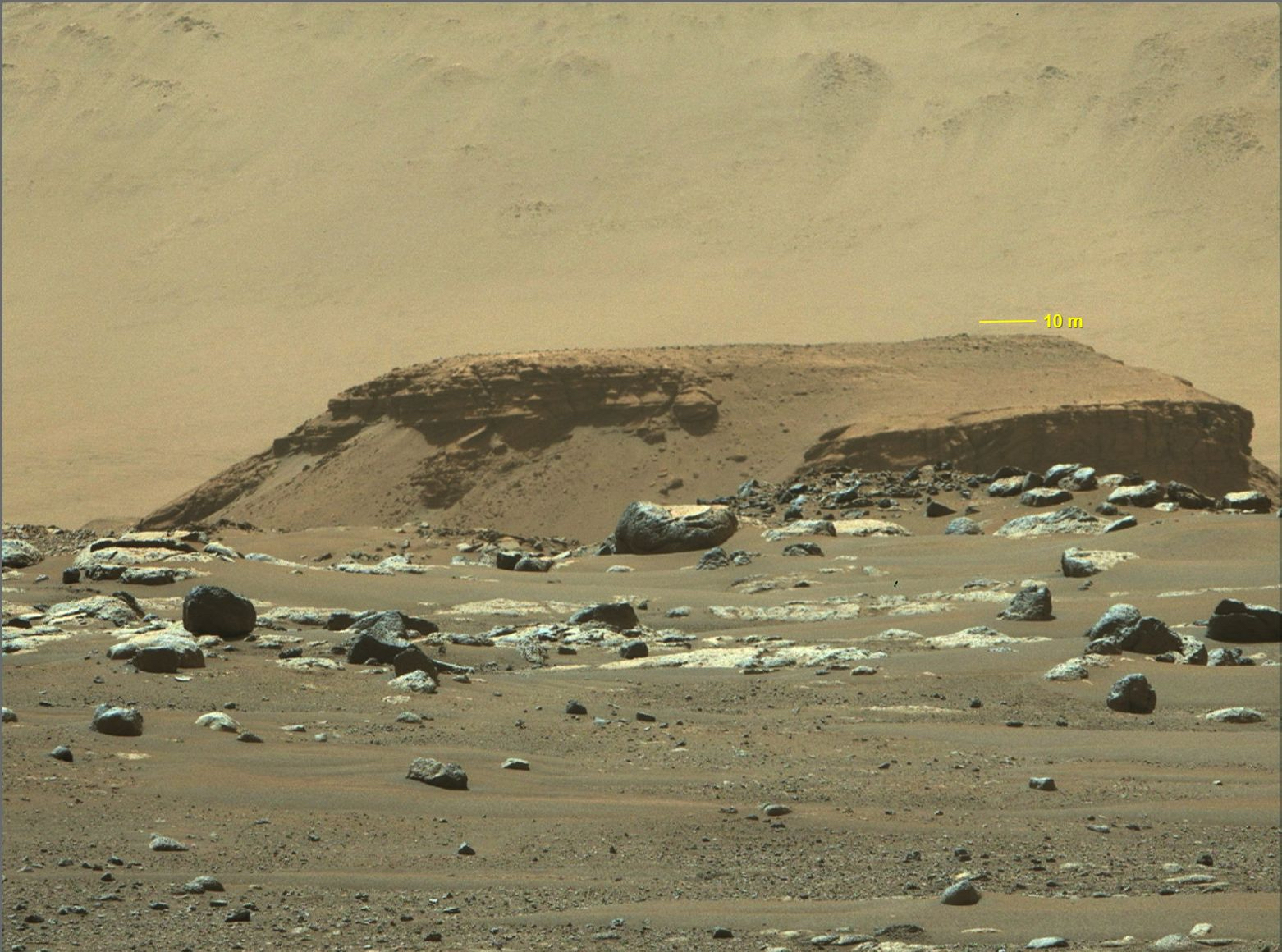
- Image B: open or download annotated image of Jezero PIA24485. Image dated February 22, 2021, with a 10 m scale bar. The record describes the color as an estimate of natural appearance. Credit: NASA/JPL-Caltech/ASU/MSSS.
These are historical archival images, not current observations. They are reused for informational and educational purposes under NASA’s media-use conditions, with credits retained and without implying institutional endorsement. For other uses, or for a version with a different rights notice, consult the conditions for that item.
Lunar activity: a map of visible features
Suggested plan: students ages 8–11, about 30 minutes; for ages 12–16, extend the justification and comparison of boundaries. The aim is to locate areas of different tones, approximately circular outlines, and a pattern of bright rays without inferring elevation from color.
- Before reading the record, draw an outline of the disk in image A. Mark a dark area and a circular feature. Describe its position as “top,” “bottom,” “left,” or “right” of the image; do not call the top north unless an indication confirms it.
- Look for the bright ray pattern in the lower part of the image. Note what you see: bright lines extending from an area, contrast with the surroundings, or recognizable outlines. If a feature cannot be distinguished in your copy, write “not visible.”
- Then read the institutional record. Relate its identification of the impact crater Tycho to the ray pattern and compare the dark area you selected with the basins filled with lava rock described in the record. Keep documented names and interpretations separate from your initial description.
- Explain why “dark” does not necessarily mean “shadow” or “water.” In this image, the information in the record and the color processing matter. Do not calculate heights or depths from tone.
Suggested answer: according to the record, the bright ray pattern in the lower area corresponds to Tycho. The dark areas described there are basins filled with lava rock, not bodies of water. Identification should be based on position and image context, not only on a feature being bright. Image A does not contain a physical scale bar for directly measuring the features in this exercise.
Mars activity: relief, scale, and interpretation
Suggested plan: students ages 12–16, about 45 minutes. For elementary school, adapt the activity to description and drawing, without calculations. The aim is to recognize the raised landform in the middle ground of image B and distinguish an observation, reading a scale, a hypothetical calculation, and a documented geological interpretation.
- Describe the foreground rocks and the more distant flat-topped landform separately. Identify edges and changes in slope that you can distinguish; do not invent layers, channels, or craters that the copy does not show.
- Locate the yellow 10 m scale bar and record its unit. Measure its length in your copy. On a separate worksheet, draw a segment twice that length: if the same linear scale were adopted for that drawing, what length would it represent? This operation is performed on a teaching diagram, not on a landscape feature.
- Do not extend that scale to foreground rocks or other features in the photograph. Perspective and different distances prevent treating them as though they were all in the same plane of a map. If the bar is unreadable or the reproduction is distorted, leave the numerical exercise unresolved. Always measure on the same copy.
- Consult the record: identify the raised area of brown rock in the middle ground as a remnant of a delta deposit. This interpretation comes from the mission documentation; observing its silhouette in a photograph does not, by itself, prove the history of water or the existence of life.
Suggested answer: there are nearby rocks and a more distant raised landform; they are not at the same distance from the camera. The bar indicates 10 m. In the separate diagram, a segment twice its length would represent 20 m if that same linear scale were imposed. This practises reading units and proportionality: it does not determine the width, height or depth of any landform in the photograph.
Compare without confusing the two views
Image A shows a lunar disk from space; image B shows a Martian landscape from the surface. Showing them at the same width on a screen does not make their scales equal. Nor does it allow students to conclude that two features of similar size on paper have the same real-world size. Compare shapes and what each view makes observable, keeping orientation, scale, and color processing separate.
To explore lighting, ask students to mark light and dark areas and propose what information they would need to distinguish terrain differences from lighting effects. If the direction of the light is not indicated, record it as unknown: a single image does not justify inventing an elevation profile. The enhanced color in A also cannot be quantitatively compared with the estimate of natural color in B.
Worksheet to copy or print
| Field | Student record |
|---|---|
| Image and provenance | A or B, identifier, credit, and image date: ____. |
| Observation | I see ____ in this part of the image: ____. |
| Scale and orientation | Scale bar available: ____. Measurements in my copy: ____. Indicated or unknown orientation: ____. |
| Documented interpretation | The record identifies ____; I distinguish this from my observation because ____. |
| Limit and next question | This image cannot determine ____. I would need ____. |
Suggested assessment: assess whether the description points to visible details, whether the measurement states its scale and limitations, and whether an interpretation identifies its documentary support. Accept “cannot be determined” when justified. For younger students, replace the table with a drawing explained orally; for older students, ask them to compare the two records and explain what new observation could resolve a question. Do not require students to guess a name or geological history from a silhouette.